

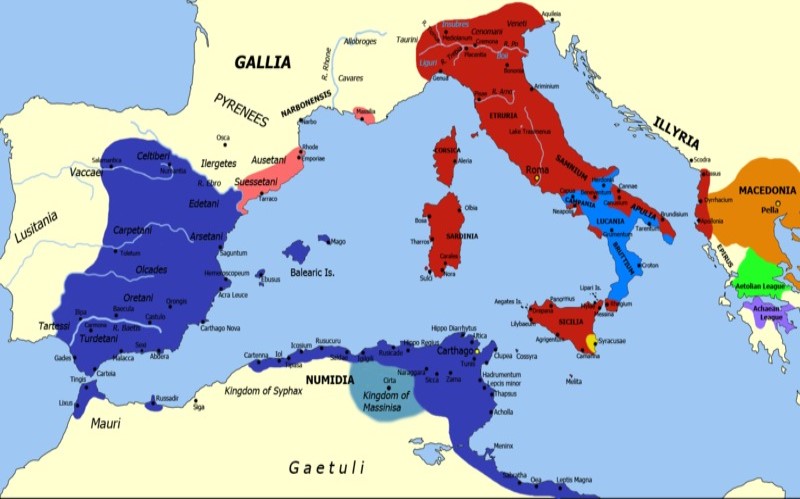
The map of Carthage Empire tells a captivating story of a civilization that once stood as a dominant power in the Mediterranean. From its origins as a small Phoenician colony in North Africa to becoming a formidable empire, Carthage shaped history with its thriving trade networks, military prowess, and rich culture. This article explores the geography, historical significance, and eventual fall of this mighty empire, all through the lens of its territorial map.
Origins of Carthage and Its Geographic Significance
Carthage was founded around 814 BCE by Phoenician settlers from Tyre, located in modern-day Lebanon. The strategic location of Carthage on the North African coast, near present-day Tunis, was pivotal. Situated on a peninsula, Carthage was surrounded by the Mediterranean Sea, offering natural protection and easy access to maritime trade routes.
The map of Carthage Empire in its early stages showed a city-state with control over surrounding agricultural lands and a burgeoning maritime presence. This geographic advantage allowed Carthage to become a hub for trade, connecting Africa, Europe, and the Middle East.
Expansion of the Carthaginian Empire
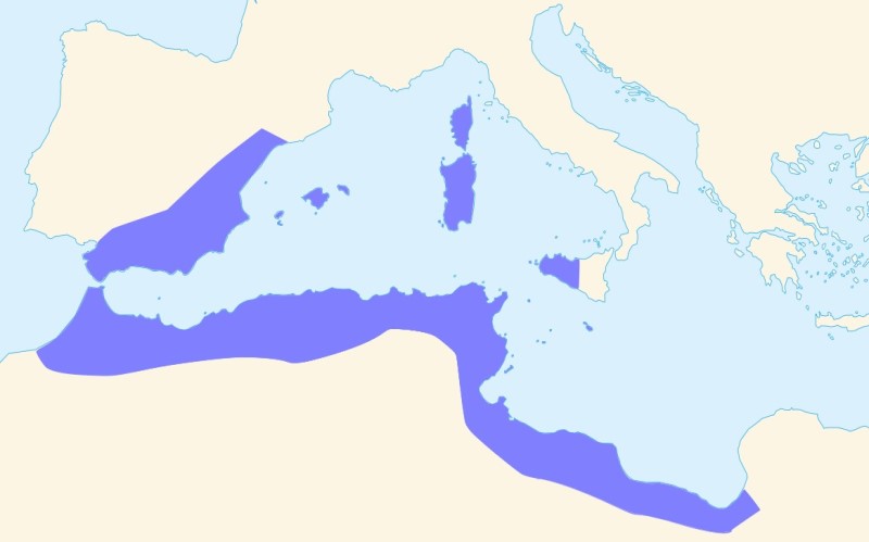
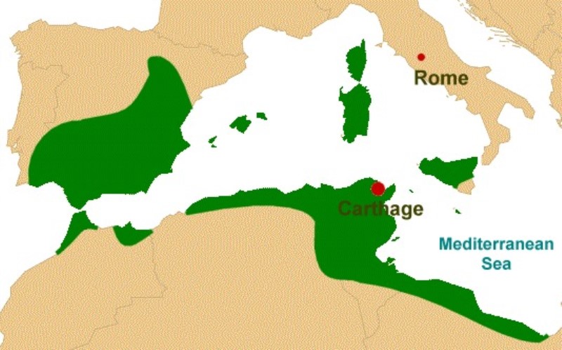
As Carthage grew in wealth and power, its influence expanded across the Mediterranean. By the 6th century BCE, the map of Carthage Empire began to include territories far beyond its initial boundaries. Here’s a look at the regions that fell under Carthaginian control:
North Africa
Carthage’s core territory stretched along the North African coast. Fertile lands supported agriculture, while coastal cities facilitated trade. The region became the heart of Carthaginian power.
Iberian Peninsula
The Carthaginians established colonies in modern-day Spain, exploiting its rich mineral resources, particularly silver. Cities like Gades (now Cádiz) became important trade and military outposts on the map of Carthage Empire.
Sicily
Control over Sicily was crucial for dominating the central Mediterranean. However, this territory also led to conflicts with Greek city-states and later Rome.
Sardinia and Corsica
These islands were significant for their strategic position and natural resources. They served as important naval bases and trade centers.
Western Mediterranean
The Carthaginian navy controlled key maritime routes in the western Mediterranean, securing trade dominance and territorial expansion.
The Role of Trade in Carthaginian Expansion
Carthage’s success was built on its ability to establish extensive trade networks. The map of Carthage Empire was dotted with trade hubs that facilitated the exchange of goods like ivory, gold, precious stones, and textiles. The Carthaginians were master shipbuilders and navigators, enabling them to control trade routes from the Atlantic Ocean to the eastern Mediterranean.
Their influence extended as far as sub-Saharan Africa, where they traded for exotic goods, and to the British Isles, where they sourced tin. This wide-reaching trade network not only enriched Carthage but also solidified its position as a Mediterranean superpower.
Military Prowess and the Punic Wars
The map of Carthage Empire reveals a history of territorial conflict, especially with its main rival, Rome. The Punic Wars were a series of three wars fought between Carthage and Rome from 264 BCE to 146 BCE, ultimately leading to Carthage’s downfall.
First Punic War (264–241 BCE)
The first conflict arose over control of Sicily. Although Carthage initially had naval superiority, Rome’s innovative tactics led to a Roman victory. This war marked the loss of Sicily on the map of Carthage Empire.
Second Punic War (218–201 BCE)
This war is most famous for Hannibal’s daring campaign. Hannibal, a brilliant Carthaginian general, crossed the Alps with his army and elephants to invade Italy. Despite his initial successes, Carthage eventually suffered defeat at the Battle of Zama, resulting in the loss of its territories in Spain.
Third Punic War (149–146 BCE)
The final war saw Rome lay siege to Carthage itself. After a brutal conflict, the city was destroyed, and the map of Carthage Empire was wiped off history, with Carthage becoming a Roman province.
Key Cities on the Map of Carthage Empire
Carthage’s empire was dotted with cities that played vital roles in its economy, culture, and military. Here are some of the most significant cities:
- Carthage (Modern Tunis): The capital and heart of the empire, renowned for its grand architecture and bustling ports.
- Utica: One of the oldest Phoenician settlements, serving as a major trade center.
- Gades (Cádiz): A vital colony in Spain known for its rich resources and military importance.
- Leptis Magna: Located in modern Libya, this city was a significant hub for trade and agriculture.
Each city contributed to the strength of the map of Carthage Empire, showcasing its vast and diverse territorial reach.
Carthaginian Culture and Contributions
Beyond its military and economic achievements, Carthage was a center of culture and innovation. The map of Carthage Empire represents not just a territorial domain but a civilization that contributed to art, architecture, and governance.
Architecture
Carthage was known for its monumental structures, including the famed harbors and walls. The city’s double harbor—a circular military port and a rectangular merchant port—was an engineering marvel.
Religion
The Carthaginians worshipped gods inherited from their Phoenician ancestors, such as Baal and Tanit. Religious practices often involved elaborate rituals and ceremonies.
Language
The Carthaginians spoke Punic, a Semitic language derived from Phoenician. The Punic alphabet influenced other Mediterranean languages.
Decline and Fall of Carthage
The fall of Carthage was a turning point in Mediterranean history. The once-thriving map of Carthage Empire was reduced to ruins by the end of the Third Punic War. Several factors contributed to this decline:
- Rivalry with Rome: The Punic Wars drained Carthage’s resources and weakened its military power.
- Economic Dependence: Over-reliance on trade made Carthage vulnerable to blockades and economic warfare.
- Internal Strife: Political instability and internal conflicts further eroded the empire’s strength.
By 146 BCE, Carthage was no longer a power on the map, marking the end of one of history’s greatest empires.
Legacy of the Carthaginian Empire
While the map of Carthage Empire no longer exists in its original form, its legacy endures. Carthaginian innovations in trade, military strategy, and urban planning influenced subsequent civilizations, including Rome. Hannibal’s military tactics are still studied in military academies, and the ruins of Carthage stand as a testament to its grandeur.
Exploring the Map of Carthage Empire Today
Modern historians and archaeologists have pieced together the map of Carthage Empire through ancient texts, ruins, and artifacts. These maps offer insights into the empire’s vastness and its strategic importance in the ancient world.
Key sites like the ruins of Carthage in Tunisia, the ancient city of Gades in Spain, and other Carthaginian settlements provide glimpses into this remarkable civilization. The reconstructed map of Carthage Empire serves as a tool for understanding its rise, dominance, and eventual fall.
Conclusion
The map of Carthage Empire is more than just a geographical representation; it is a window into a civilization that shaped Mediterranean history. From its strategic location in North Africa to its vast trade networks and military conquests, Carthage was a beacon of culture, innovation, and power.
Although Carthage ultimately fell to Rome, its legacy continues to inspire historians and enthusiasts alike. Exploring the map of Carthage Empire allows us to appreciate the complexities of ancient civilizations and their enduring impact on the world.
